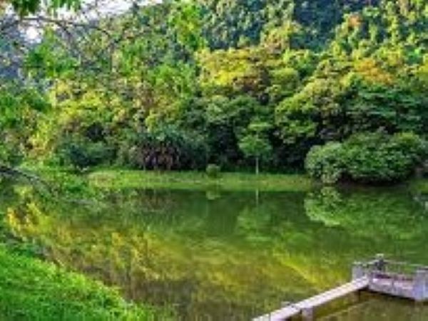
About Ninh Binh
Located as far as 100 kilometers south of Hanoi, marking Ninh Binh province, the southernmost point of the Red River delta. Within the province lies the majestic Tam Diep Mountain, connecting the North and the South. The province extends from the mountainous northwest region to the delta, thus being called a half mountainous and half plain. Notably, Ninh Binh contains 3 main kinds of topography: captivating limestone mountains with caves & grottos, a delta formed by the Red River, and a coastline with a length of 18 kilometers, enlarging the province's area by 100m2 annually. Besides limestone caves and grottos, Ninh Binh is renowned for being the first imperial capital, which existed from 968 to 1010 under Dinh, Le, and Ly dynasties, which has resulted in its cultural tourism. Moreover, Tam Coc-Bich Dong and Cuc Phuong National Park within the province are desirable destinations for tourists. Would you like to visit Ninh Binh? Please be willing to join the following trip.
Briefings..,
Hoa Lu, the inaugural imperial capital of Vietnam
The very first significant stopover in Ninh Binh is Hoa Lu, the former capital of Vietnam from 968 to 1010. Before the year 968, the nation was merely a Chinese district. Over time, various struggles for independence took place, but none was of a long successful until Dinh Bo Linh’s forces. In 968, Dinh Bo Linh defeated 12 lords of the district (former Vietnam) and proclaimed himself Emperor. He was the first King of the Dinh dynasty (King Dinh Tien Hoang), and named the country Dai Co Viet. Then he established Hoa Lu, his homeland, as the capital of Dai Co Viet. His significant success marked a great landmark for Vietnam, transitioning from a district of China to a truly independent nation.
Dinh dynasty lasted for 12 years. Then Le Hoan initiated the 29 years of the Le dynasty. In 1009, when Ly Cong Uan ascended to the throne, he discovered an area with an excellent site and topography, therefore deciding to relocate the capital from Hoa Lu to Dai La citadel, the former Hanoi. In 1910, Hoa Lu relinquished its honored role as the Nation’s Capital after 42 years. Today, tourists come to Hoa Lu for the purpose of involving themselves in the historical and enigmatic world of an ancient capital with a magnificent palace, a mighty citadel, nestled amidst the grandeur of mountain ranges and the serene Hoang Long rivers. This creates a splendid fairy-tale scenery!


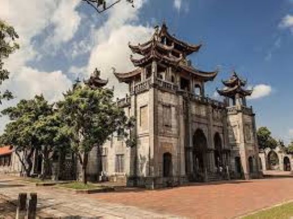
King Dinh Tien Hoang’s Temple
It is now time to visit the King of Vietnam’s temple – King Dinh Tien Hoang’s. The temple is situated in Truong Yen village, Truong Yen commune, Hoa Lu town, within a 5 hectares wide area. It faces the East and stands in front of Ma Yen Mount, where King Dinh Tien Hoang’s tomb is located.
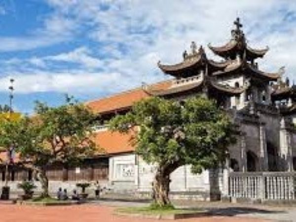
The temple was built in the 17th century with unique architecture, with an interior of which had an “I letter” surrounded by a square courtyard. You are currently at the 3-class mid-noon gate. You can proceed to the next gate, seeing a dragon bed before reaching the second gate. Passing through one more gate and strolling along the sacred path will lead you to the main hall. In the center of the house, is another stone dragon bed measuring 1.8m in length and 1.4m in width. Upon examining the bed's surface, you can easily find sculptured dragon, shrimp, fish, and rat images, showcasing deep delicateness and craftsmanship.
The main house consists of 3 parts. The first part is the worshipping place with 5 rooms. The second part is an incense-burning room where 4 important mandarins under the Dinh dynasty. The third main part, the most important part is separated from the second by a high door. Here, you can witness the worshipping of King Dinh Tien Hoang and his three sons.
You may have to admit that the temple is an original architectural work of art filled with folk sculptures. It attracts tourists for so many valuable relics hidden in thick bricks, tiles, Buddhist prayer-book pillars, and, more importantly, its meaningful history as the first ancient capital of Vietnam.
Nearby, you can find the Tomb of King Dinh Tien Hoang, situated on Ma Yen Mount, in front of his Temple. “Ma horse's yen” means “back of a horse”; as seen from a distance, it resembles the shape of a back of a horse. The tomb is located on the sagging post of the horse’s back. To reach the tomb, visitors must climb 150 rock steps. It was built in 1840, under Ming Mang King Ming Mang.


Phat Diem Cathedral – symbol of a rich religious life
If you are Catholic, a famous Cathedral to visit in Ninh Binh is Phat Diem Cathedral, which was constructed between 1875 and 1899 with four roofs and six sets of iron wooden pillars. It consists of a network of ponds, lakes, churches, and artificial caves. On both sides of the church, there are four smaller churches of different styles. In the area, the rice paddies are dotted with stone churches. However, unlike these structures, which were built by Europeans and resemble typical churches of the era, Phat Diem Cathedral was designed by a Vietnamese priest known as Father Sau. Father Sau mobilized the local population to build the cathedral, five side chapels, three artificial grottoes, an artificial lake, and a bell tower. Phat Diem Cathedral seems to have changed very little since Graham Greene described its gigantic pillars formed out of single trees and the scarlet lacquer work of the altar. Indeed, with its multi-tiered, curling roofs and its 48 lime-wood columns (the largest of which weigh seven tons), Phat Diem is a far cry from a European cathedral. Stone relief angels overlook carved dragons, and the cathedral's two-tone bell is accompanied by a giant brass gong.
Whoever spends a few minutes inside the Cathedral, particularly the Stone Church, can easily feel the specially cool atmosphere and a classical religious space!
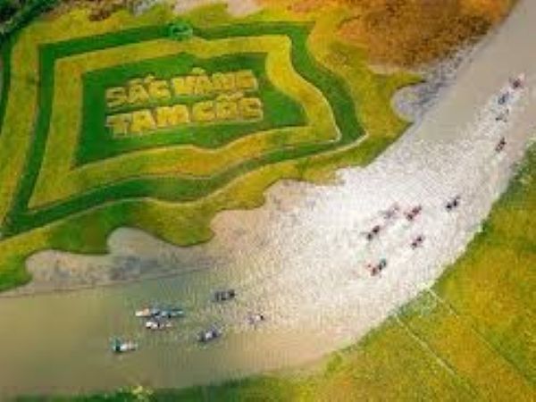
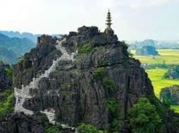
Tam Coc – Bich Dong - “South second nicest grotto”
Tam Coc – Bich Dong is called “A terrestrial Ha Long Bay”, or the “South second nicest grotto” (to Huong Tich) for its poetic and inspirational natural scenery of beauty. It is a grandiose complex of Bich Dong pagoda and Tam Coc grotto. King Le Canh Hung once said: “This is “the South second nicest grotto of Vietnam, after the Huong Tich Grotto in Ha Tay province”. Its pristine natural beauty together with a simple but nice countryside landscape, and a sacred spiritual life have converged into a fascinating and attractive Tam Coc-Bich Dong for numerous tourists.
These days, more and more people in the world have been coming here on various types of tours: ecological tours, cultural, historical tours (such as Thai Vi Temple, Bich Dong Pagoda, Linh Coc Pagoda, Thien Huong Cave, Fairy Cave.. festivals). No one could deny that Tam Coc-Bich Dong has become a legend of rivers and mountains, a green, pure, and safe destination for every traveler.

Cuc Phuong National Park
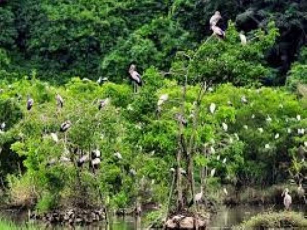
Ninh Binh boasts Cuc Phuong National Park, the largest & first national park of Vietnam, and one of the most important sites for biodiversity within the country. It is home to hundreds of species of flora and fauna. Inhabitants of the park include 97 species of mammals, most notably the endangered langurs; 300 species of birds; 36 reptilian species; 17 species of amphibians; 11 species of fish; 2,000 species of vascular plants, and thousands of species of insects, most of which do not bite. A number of species in the park are listed in the Vietnam Red Book of endangered species.
Exploration of Cuc Phuong's many limestone caves makes a rewarding excursion. The caves include Thang Khuyet Cave, Con Moong Cave, Pho Ma Cave, Nguoi Xua Cave, and the Cave of Prehistoric Man (Dong Nguoi Xua). The Botanical Garden located near the park’s headquarters is a good place to take a stroll and get an introduction to the region’s flora. Early in the morning, you can hear birds singing, accompanied by perhaps a gibbon or two. The Endangered Primate Rescue Center is an important rehabilitation center for Vietnam's critically endangered and majestic primates. Langurs, lorises, and gibbon species are housed at the center and include the critically endangered Delacour's Langur, Golden-Headed Langur, Tonkin Snub-Nosed Monkey, and Black Crested Gibbon.
Tourists coming to Ninh Binh are mostly eager to pay a visit to Cuc Phuong for exploring a pure ecological space of the locality!
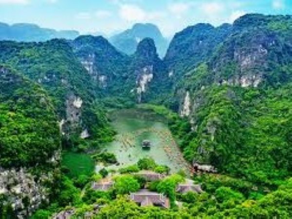
Trang An Landscape Complex
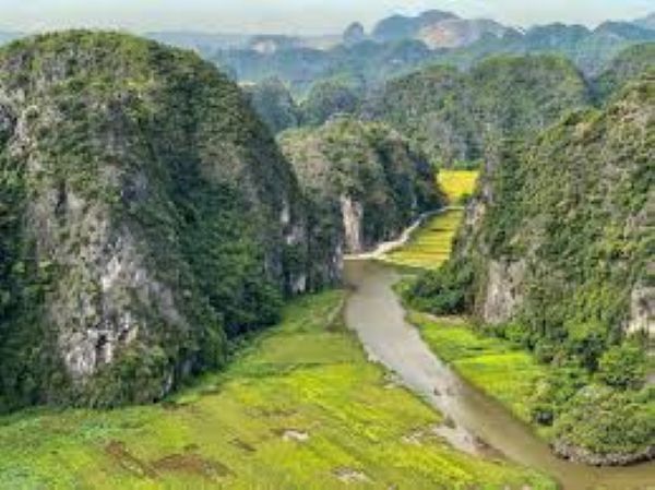
Situated near the southern margin of the Red River Delta, the Trang An Landscape Complex is a spectacular landscape of limestone karst peaks permeated with valleys, many of them partly submerged and surrounded by steep, almost vertical cliffs. Exploration of caves at different altitudes has revealed archaeological traces of human activity over a continuous period of more than 30,000 years. They illustrate the occupation of these mountains by seasonal hunter-gatherers and how they adapted to major climatic and environmental changes, especially the repeated inundation of the landscape by the sea after the last ice age. The story of human occupation continues through the Neolithic and Bronze Ages to the historical era. Hoa Lu, the ancient capital of Viet Nam, was strategically established here in the 10th and 11th centuries AD. The property also contains temples, pagodas, paddy fields, and small villages.
Located within Ninh Binh Province of North Vietnam near the southern margin of the Red River Delta, the Trang An Landscape Complex (Trang An) is a mixed cultural and natural property contained mostly within three protected areas: the Hoa Lu Ancient Capital, the Trang An-Tam Coc-Bich Dong Scenic Landscape, and the Hoa Lu Special-Use Forest. The property covers 6,226 hectares within the Trang An limestone massif and is surrounded by a buffer zone of 6,026 hectares, mostly rural land with rice paddy fields. There are about 14,000 residents, the majority of whom are families involved in subsistence agriculture, but much of the property is uninhabited and in a natural state.
Trang An is of global significance as an outstanding humid tropical tower-karst landscape in the final stages of geomorphic evolution. It is composed of a variety of classical karst cones and towers and a network of enclosed depressions connected by an intricate system of subterranean waterways, some of which are navigable by small boats. The area is unique in having been invaded by the sea several times in the recent geological past but is now emergent on land. The blend of towering mountains draped in natural rainforest, with large internal basins and narrow cave passages containing quietly flowing waters, creates an extraordinarily beautiful and tranquil landscape.
Archaeological deposits in caves reveal a regionally significant, continuous sequence of human occupation and utilization spanning more than 30,000 years. There is convincing evidence showing how early human groups adapted to changing landscapes in the massif, including some of the most extreme climatic and environmental changes in the planet’s recent history.

Criterion (v): Trang An is an outstanding locale within Southeast Asia for demonstrating the way early humans interacted with the natural landscape and adapted to major changes in climatic, geographical, and environmental conditions over a period of more than 30,000 years. The long cultural history is closely associated with the geological evolution of the Trang An limestone massif in the late Pleistocene and early Holocene times, when the inhabitants endured some of the most turbulent climatic and environmental changes in Earth history, including repeated submergence of the landscape due to oscillating sea levels. Within the one compact landscape, there are many sites covering multiple periods and functions, comprising early human settlement systems.
Criterion (vii): The exceptionally beautiful tower-karst landscape of Trang An is dominated by a spectacular array of forest-mantled limestone rock towers up to 200m high, which are linked in places by sharp ridges enclosing deep depressions filled by waterways that are interconnected by a myriad of subterranean cave passages. These features all contribute to a multi-sensory visitor experience that is heightened by contrasting and ever-changing colors - the deep green tropical rainforests, grey limestone rocks and cliffs, blue-green waters, and the brilliant blue of the sky, and areas of human use including the green and yellow rice paddies. Visitors, conveyed in traditional sampans rowed by local guides, experience an intimate connection with the natural environment and a relaxing sense of serenity and security. The dramatic mountains, secretive caves, and sacred places in Trang An have inspired people through countless generations.
Criterion (viii): Trang An is a superb geological property that displays, in a globally exceptional way, the final stages of tower-karst landscape evolution in a humid tropical environment. Deep dissection of an uplifted limestone massif over a period of five million years has produced a series of classical karst landforms, including cones, towers, enclosed depressions (cockpits), interior-draining valleys (poljes), foot- caves and subterranean cave passages decorated with speleothems. The presence of transitional forms between ‘fengcong’ karst with ridges connecting towers, and ‘fenglin’ karst where towers stand isolated on alluvial plains, is an extremely significant feature of the property. Trang An is an unusual autogenic karst system, being rain-fed only and hydrologically isolated from rivers in the surrounding terrain. Former inundation by the sea transformed the massif into an archipelago for some periods, though it is fully emergent on land today. Fluctuations of sea level are evidenced by an altitudinal series of erosion notches in cliffs, with associated caves, wave-cut platforms, beach deposits, and marine shell layers.
Integrity
The property is of sufficient size and scope to encompass almost the entire limestone massif, with a full range of classic tower-karst landforms and associated geomorphic processes. All caves and other sites known to be of archaeological significance are included. The very rugged topography has generally isolated the property from intensive occupation and utilization, and much of its interior remains in a natural state. Within the extensive natural areas of the property, there are no structures that obstruct the scenery or detract from the aesthetic appeal. Occupied areas are mainly small traditional villages and associated gardens and rice paddy fields tended by subsistence farmers. The greater part of the property is enclosed within three officially designated protected areas and contains a number of other sites protected by Government Decree. A large buffer zone surrounds the property and is designed to protect it from external impacts. It contains many small villages together with gardens, farms, and rice paddies, and also the recently reconstructed Bai Dinh Pagoda complex.
Trang An is a relatively small property that supports a resident population and is host to a large and growing number of tourist visitors. Close monitoring, strict regulation, and careful management will be required in the long term to avoid pressures and threats from urban expansion, resource use, village growth, excessive tourist infrastructure and use, and service development. These are among the key issues given priority attention in the property management plan.
Authenticity
Knowledge of the ancient inhabitants of Trang An, their culture, and relationship to the landscape primarily comes from archaeological investigation and excavation in caves within the massif, which are still largely in their original condition – a rarity in Southeast Asia. The rich archaeological resources are predominantly midden accumulations containing shells, animal bones, stone tools, hearths, corded-ware pottery, and occasionally human remains. The sites are yielding vivid paleo-environmental records from the analysis of pollen, seeds, and plant tissue, fauna, and geomorphic evidence of ancient shorelines. These studies are supported by sophisticated modern techniques such as geochemical analysis of plant carbon isotopes and lipids, shell oxygen isotopes, and the pioneering use in Southeast Asia of LiDAR (Light Distancing and Ranging) to create millimeter-accurate images of cave sites. All materials are professionally plotted, collected, cataloged, stored, and analyzed. The results of studies have been communicated through an impressive portfolio of published scientific papers and are also reported in a definitive monograph on human adaptation in the Asian Palaeolithic, the author, who has conducted research in Trang An for almost a decade.
Protection and Management Requirements
Trang An is state-owned and controlled by the Ninh Binh Provincial People’s Committee. Most of the property is secured within three statutory protected areas: the Hoa Lu Ancient Capital, the Trang An-Tam Coc-Bich Dong Scenic Landscape, and the Hoa Lu Special-Use Forest. Six primary national laws and a series of government decrees provide measures for the administration and management of the property, protection of cultural heritage, monuments, relics, archaeological sites and resources, biodiversity conservation, environmental protection, eco-tourism, other commercial activities, and sustainable socio-economic development. The property is managed by the Trang An Landscape Complex Management Board, an independent agency with extensive decision-making powers, responsibilities, and resources, and with close functional links to government ministries, research institutes, and commercial and community stakeholders.
Management is guided by a comprehensive, government-approved, and legally binding management plan prepared in consultation with the public and key stakeholders. The plan adopts a zoning system that allows for management prescriptions to be more effectively aligned with the varying protection and use requirements in different parts of the property. A long-term lease delegates authority to a private company for some aspects of conservation and tourism management in the Trang An-Tam Coc-Bich Dong Scenic Landscape area. There are four small private tourist resort operations within the property. Ongoing management priorities include extended monitoring and control of tourist operations, development of better visitor centers and services, ongoing research along with improved archaeological site conservation, database development, and collection, storage, and display of artifacts, expansion of training, education, awareness-raising, and promotion programs, and support for social and economic development of local communities through employment opportunities, and more effective sustainable use and conservation of natural resources.
VIETNAM FUNNY TRAVEL
More than a trip !
